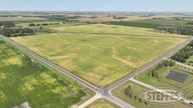
LYON COUNTY, MN – MONROE TOWNSHIP
Total Acres: 176.6±
PID #: 13-022004-0 & 13-022006-0
To Be Sold in 2 Tracts!
Wind Easement Agreement (See Agreement)
Private & county tile (See Map)
TRACT 1:
Description: The Southeast Quarter of the Northwest Quarter (SE¼ NW¼) of Section 22, Township 109 North, Range 40 West, EXCEPT the West One(1) acre thereof. AND ALSO A tract of land in the southwest comer of the Southwest Quarter of the Northeast Quarter (SW¼ NE¼) of Section 22, Township 109 North, Range 40 West of the fifth Principal Meridian, described as follows: Beginning at the southwest comer of said SW¼ NE¼; thence running North 33½ feet; thence in a southeasterly direction to a point on the South line of said SW¼ NE¼, 33½ feet east of the southwest comer thereof; and thence West to the point of beginning. AND ALSO The Southeast Quarter of Section 22, Township 109 North, Range 40 West of the Fifth Principal Meridian lying northerly of the northerly right of way line of the railroad EXCEPT A tract in the northeast comer of the SE¼ containing 6-3/8 acres described as follows: Commencing at the northeast comer of said SE¼; running thence West on the North line thereof a distance of 40 rods; thence at right angles South a distance of 25 rods and 8 feet; thence at right angles and to the east a distance of 40 rods to the East line of said quarter section; thence North along the East line to the point of beginning.
Total Acres: 115.5± (See Survey)
Cropland Acres: 67.30±
PID #: 13-022004-0 (That part of, new legal & PID# to be assigned) & 13-022006-0
Soil Productivity Index: 92.8
Soils: North TwinWalnut Grove complex, 0 to 2 percent slopes (36.8%), Pell CreekRomnell complex, 0 to 2 percent slopes (31.4%), North TwinWalnut Grove complex, 1 to 4 percent slopes (26.3%), Romnell silty clay loam, depressional, 0 to 1 percent slopes (5.4%), Moines clay loam, 1 to 3 percent slopes (0.1%)
Taxes (2024): $7,024.00 (For entire land. New tax amount TBD)
30.45± in CRP, $298.89/acre, contract through 9-30-2031 (See Contract)
TRACT 2:
Description: The Southeast Quarter of Section 22, Township 109 North, Range 40 West of the Fifth Principal Meridian lying southerly of the southerly right of way line of the railroad EXCEPT That part of the Southeast Quarter (SE¼) and the Southeast Quarter of the Southwest Quarter (SE¼ SW1/,) of Section 22, Township 109 North, Range 40 West of the Fifth Principal Meridian, more particularly described as follows: Beginning at the point of intersection of the South line of said Section 22 and the southerly right-of-way of the Chicago and Northwestern Railroad; thence East along the South line of said Section 22 a distance of 1,320 feet; thence North, parallel with the East line of said Section 22, to a point of intersection with the southerly right-of-way of the Chicago and Northwestern Railroad; thence in a southwesterly direction along the southerly right-of-way of the Chicago and Northwestern Railroad to the point of beginning, consisting of 12.47 acres, more or less and subject to highways and easements of records.
Total Acres: 61.1± (See Survey)
Cropland Acres: 57.40±
PID #: 13-022004-0 (That part of, new legal & PID# to be assigned)
Soil Productivity Index: 93.3
Soils: North TwinWalnut Grove complex, 0 to 2 percent slopes (40.7%), Pell CreekRomnell complex, 0 to 2 percent slopes (29.8%), North TwinWalnut Grove complex, 1 to 4 percent slopes (29.5%)
Taxes (2024): $5,930.00 (For entire land. New tax amount TBD)
TERMS: Ten percent down upon signing purchase agreement, payable by cash or check. Balance due at closing which will be after January 1, 2025. There is NO buyer’s premium on this auction.
CONTACT
Andy Frank at Steffes Group (507) 828-1322 or Ashley Huhn at Steffes Group (701) 238-1975 or (320) 693-9371
Steffes Group, Inc, 23579 MN Hwy 22 South, Litchfield, MN 55355