Weldon, IA
Bidding Opens: Wednesday, October 25th
Bidding Closes: Wednesday, November 1, 2023 at 2PM
562± Acres – Sells in 8 Tracts
Selling Free & Clear of Hunting Rights
Auctioneer’s Note: Seeking a hunting property that also generates income? Explore this land auction boasting an impressive annual CRP income exceeding $60,000! In this timed online auction, you'll find a range of tract sizes to select from, enabling you to pick the perfect fit for your hunting and recreational desires.
Tract 2 – 159.66± Surveyed Acres
Located 7 miles east of Weldon on Highway 266, then 0.7 miles north on 320th Ave.
- FSA indicates: 130.87 cropland acres all of which are in CRP as follows:
108.65 acres X $195.73 = $21,266.00 and expires on 9-30-2027.
22.22 acres X $105.00 = $2,333.00 and expires on 9-30-2030.
- Corn Suitability Rating 2 is 40.5 on the cropland acres.
- The land has terraces and two wells on property.
- The land has a pond and a creek running through the property.
- Located in Section 35, Franklin Township, Clarke County, Iowa.
- Tax Parcels 08989, 08990, 08991, Part of 08992 = $2,165.00 Approx. Net
View FSA 156 EZ Form
View Tract 2 - FSA Field Map
View Tract 2 - CRP Contract 1
View Tract 2 - CRP Contract 2
View Tract 2 - Soil Map
View Tract 2 - Survey Overlay
View Tract 2 - Survey Plat
Tract 3 - 38.69± Acres
Located 7 miles east of Weldon on Highway 266, then 3.5 miles north on 320th Ave, then 0.4 miles east on Mormon Trail.
- FSA indicates: 24.45 cropland acres all of which are in CRP as follows:
13.36 acres X $197.85 = $2,643.00 and expires on 9-30-32.
11.09 acres X $206.95 = $2,295.00 and expires on 9-30-28.
- Corn Suitability Rating 2 is 67.7 on the cropland acres.
- Balance of land being pasture & timber ground.
- History lesson, this property was a stage coach stop.
- Located in Section 14, Franklin Township, Clarke County, Iowa.
- Tax Parcel 08698 = 718.00 Net
View FSA 156 EZ Form
View Tract 3 - FSA Field Map
View Tract 3 - CRP Contract 1
View Tract 3 - CRP Contract 2
View Tract 3 - Soil Map
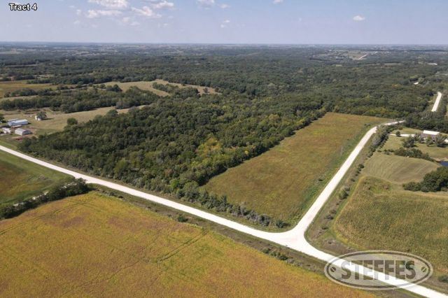
Tract 4 - 33.76± Acres
Located 7 miles east of Weldon on Highway 266, then 3.5 miles north on 320th Ave, then 0.8 miles east on Mormon Trail.
- Approx: 8.24 cropland acres all of which are in CRP as follows:
8.24 acres X $222.43 = $1,832.82 and expires on 9-30-28.
- Corn Suitability Rating 2 is 59.3 on the cropland acres.
- Seller states this property has a spring.
- Located in Section 14, Franklin Township, Clarke County, Iowa.
- Tax Parcels 08696, 08697 = $216.00 Net
View FSA 156 EZ Form
View Tract 4 & 5 - FSA Field Map
View Tract 4 & 5 - CRP Contract
View Tract 4 - Soil Map
Tract 5 - 90.87± Acres
Located 7 miles east of Weldon on Highway 266, then 3.5 miles north on 320th Ave, then 0.9 miles east on Mormon Trail, then 0.3 miles north on 330th Ave.
- Approx: 1.2 cropland acres all of which are in CRP as follows:
1.2 acres X $222.43 = $266.92 and expires on 9-30-28.
- Corn Suitability Rating 2 is 65.8 on the cropland acres.
- Balance of land is timber with a pond and a creek running through the property.
- This land borders Stephens State Forest – Woodburn Unit.
- Located in Sections 11 & 14, Franklin Township, Clarke County, Iowa.
- Tax Parcels 08552, 08554, 08699, 08695 = $56.00 Net
View FSA 156 EZ Form
View Tract 4 & 5 - FSA Field Map
View Tract 4 & 5 - CRP Contract
View Tract 5 - Soil Map
Tract 6 - 59.64± Surveyed Acres
Located 2 miles east of Weldon on Highway 266, then 5.3 miles north on 270th Ave, then 2.3 miles east on Elk St., then 0.7 miles south on 285th Ave.
- FSA indicates: 28.37 cropland acres all of which are in CRP as follows:
28.37 acres X $122.00 = $3,461.14 and expires on 9-30-2030.
- Corn Suitability Rating 2 is 79.2 on the cropland acres.
- Balance of land is timber with a creek running through the property.
- Located in Sections 7 & 8, Franklin Township, Clarke County, Iowa.
- Tax Parcels 08463, Part 08492 = $1,069.00 Approx. Net
View FSA 156 EZ Form
View Tract 6, 7 & 8 - FSA Field Map
View Tract 6, 7 & 8 - CRP Contract
View Tract 6 - Soil Map
View Tracts 6, 7 & 8 - Survey Overlay
View Tracts 6, 7 & 8 - Survey Plat
Tract 7 - 76.99± Surveyed Acres
Located 2 miles east of Weldon on Highway 266, then 5.3 miles north on 270th Ave, then 2.3 miles east on Elk St., then 0.7 miles south on 285th Ave.
- FSA indicates: 61.68 cropland acres all of which are in CRP as follows:
49.05 acres X $122.00 = $5,984.10 and expires on 9-30-2030.
12.63 acres X $207.83 = $2,624.89 and expires on 9-30-2024.
- Corn Suitability Rating 2 is 69.7 on the cropland acres.
- Balance of land is timber with a creek bordering the property.
- Seller states drain ditches have tile.
- Located in Section 8, Franklin Township, Clarke County, Iowa.
- Tax Parcels 08494, Part 08492, Part 08493, Part 14140 = $1,560.00 Approx. Net
View FSA 156 EZ Form
View Tract 6, 7 & 8 - FSA Field Map
View Tract 6, 7 & 8 - CRP Contract
View Tract 7 & 8 - CRP Contract
View Tract 7 - Soil Map
View Tracts 6, 7 & 8 - Survey Overlay
View Tracts 6, 7 & 8 - Survey Plat
Tract 8 – 64.81± Surveyed Acres
Located 2 miles east of Weldon on Highway 266, then 5.3 miles north on 270th Ave, then 2.3 miles east on Elk St., then 0.9 miles south on 285th Ave.
- FSA indicates: 46.79 cropland acres all of which are in CRP as follows:
21.72 acres X $305.35 = $6,632.00 and expires on 9-30-2024.
19.12 acres X $207.83 = $3,973.71 and expires on 9-30-2024.
5.95 acres X $122.00 = $725.90 and expires on 9-30-2030.
- Corn Suitability Rating 2 is 51.2 on the cropland acres.
- Located in Section 8, Franklin Township, Clarke County, Iowa.
- Tax Parcels Part 08492, Part 08493, Part 14140 = $1,023.00 Approx. Net
View FSA 156 EZ Form
View Tract 6, 7 & 8 - FSA Field Map
View Tract 6, 7 & 8 - CRP Contract
View Tract 7 & 8 - CRP Contract
View Tract 8 - CRP Contract
View Tract 8 - Soil Map
View Tracts 6, 7 & 8 - Survey Overlay
View Tracts 6, 7 & 8 - Survey Plat
Terms: 10% down payment on November 1, 2023. Balance due at final settlement with a projected date of December 15, 2023, upon delivery of merchantable abstract and deed and all objections having been met.
Possession: Projected date of December 15, 2023.
Real Estate Taxes: To be prorated to date of possession on the basis of the last available tax statement. The seller shall pay any unpaid real estate taxes payable in prior years.
Special Provisions:
Sellers: Perry A. & Reva M. Heston