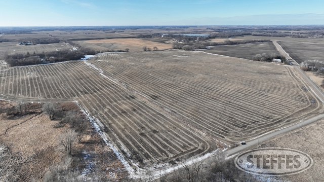
127± acres of productive farmland with a CPI of 83 coming up on public auction in Greenleaf Township, Meeker County, MN. This property presents a fantastic opportunity for those looking to expand their current operation or invest in quality agricultural land. Additionally, the land offers the possibility to build your dream home in the country. Don’t miss this chance to secure a valuable piece of farmland with great potential!
SOLD $845,397.00
LAND LOCATION
From Litchfield, MN, 5.8 miles south on MN-22 S/Sibley Ave, .2 miles west on 205th St., .5 north on 624th Ave. Land is on the west side of the road.
OPENING: Wednesday, March 5
CLOSING: Wednesday, March 12, beginning at 1:00pm CDT
AUCTION INFORMATION
MEEKER COUNTY, MN - GREENLEAF TOWNSHIP
Description: The North Half of the Northeast Quarter (N1/2 of the NE1/4) of Section 11, Township 118 North, Range 31 West, Meeker County, Minnesota, lying westerly of 624th Avenue, formerly County Road No. 288 and formerly State Highway No. 22, EXCEPT Blaha's North Shore, according to the plat thereof on file and of record in the office of the Register of Deeds in and for Meeker County, Minnesota. AND That part of Government Lot 1 and that part of Government Lot 2, all being in Section 11, Township 118 North, Range 31 West, Meeker County, Minnesota, lying northerly of the following described line: Commencing at the North Quarter corner of said Section 11; thence on an assumed bearing of South 00 degrees 23 minutes 44 seconds East along the west line of said N1/2 of the NE1/4 and the west line of said Government Lot 2, a distance of 3117.57 feet to the point of beginning of the line herein described; thence North 79 degrees 20 minutes 31 seconds East, a distance of 394.25 feet; thence North 08 degrees 10 minutes 42 seconds West, a distance of 102.44 feet; thence North 63 degrees 23 minutes 29 seconds East, a distance of 275.41 feet; thence South 88 degrees 00 minutes 45 seconds East, a distance of 299.65 feet; thence North 22 degrees 46 minutes 01 second East, a distance of 383.84 feet; thence North 65 degrees 04 minutes 49 seconds East, a distance of 628. 10 feet; thence North 37 degrees 09 minutes 28 seconds East, a distance of 435. 15 feet; thence North 89 degrees 17 minutes 27 seconds East, a distance of 755.46 feet to the east line of said Government Lot 1 and said line terminating thereat. EXCEPT Blaha's North Shore, according to the plat thereof on file and of record in the office of the Register of Deeds in and for Meeker County, Minnesota. ALSO EXCEPT Part of Government Lot Two (2), Section Eleven (11 ), Township One Hundred Eighteen (118) North, Range Thirty-one (31) West, Commencing 164.0 feet south of the Northwest comer of Government Lot Two (2) to the point of beginning, thence due South along the west line of said Government Lot Two (2), 777.0 feet, thence due East, 625.0 feet, thence due North 777.0 feet, thence due West 625.0 feet to the point of beginning.
PID #: 11-0130000 (That part of, new legal & PID# to be assigned)
Soil Productivity Index: 83.9
Soils: ClarionSwanlake complex, 2 to 6 percent slopes (16.3%), Uniongrove loam, 0 to 2 percent slopes (10.8%), ClarionStordenHawick complex, 2 to 6 percent slopes (8.9%), Wadenill loam, 2 to 6 percent slopes (8.7%), WadenillSunburg complex, 2 to 6 percent slopes (8.6%), Webster clay loam, 0 to 2 percent slopes (8.3%), HamelGlencoe complex, 0 to 2 percent slopes (6.5%), EsthervilleHawick complex, 2 to 6 percent slopes (4.7%), Harps clay loam, 0 to 2 percent slopes (4.4%), Estherville sandy loam, 0 to 2 percent slopes (3.4%), Cylinder loam, 0 to 2 percent slopes (3.1%), StordenOmsrud complex, 6 to 12 percent slopes, eroded (3.1%), Glencoe clay loam, 0 to 1 percent slopes (2.9%), Nicollet clay loam, 1 to 3 percent slopes (2.1%), Wadena loam, 0 to 2 percent slopes (2.0%), Klossner muck, 0 to 1 percent slopes (1.8%), CanisteoGlencoe complex, 0 to 2 percent slopes (1.7%), DanielsonDanielson, overwash complex, 1 to 4 percent slopes (1.1%), MayerBiscay, depressional complex, 0 to 2 percent slopes (0.8%), OmsrudStorden complex, 10 to 16 percent slopes, moderately eroded (0.8%)
Taxes (2024): $6,338.00 (For entire land. New tax amount TBD)
Per Meeker County has one building entitlement
Easement for ingress and egress purposes
Easement for electrical facilities purposes. TERMS:Ten percent down upon signing purchase agreement, payable by cash or check. Balance due at closing within 30 days. This is a 5% buyer’s premium auction.
CONTACT
Eric Gabrielson at Steffes Group, (701) 238-2570 or (320) 693-9371