BENTON, SHERBURNE AND DOUGLAS COUNTIES
Total Acres: 1215±
PID #s: 01.00256.01 (That part of, new legal & PID# to be assigned), 01.00333.00 (That part of, new legal & PID# to be assigned), 01.00334.00 (That part of, new legal & PID# to be assigned), 01.00335.00 (That part of, new legal & PID# to be assigned), & 01.00337.00 (That part of, new legal & PID# to be assigned), 07.00235.00, 07.00236.00, 07.00241.00 & 07.00251.00 (That part of, new legal & PID# to be assigned), 08.00388.00 (That part of, new legal & PID# to be assigned), 03.00146.00 & 03.00148.01, 03.00149.00, 03.00138.00, 03.00133.00, 05-00108-1400, 05-00118-1300 & 05-00118-1100, 05-00118-4100, 51-0217-000
To Be Sold in 14 Tracts!
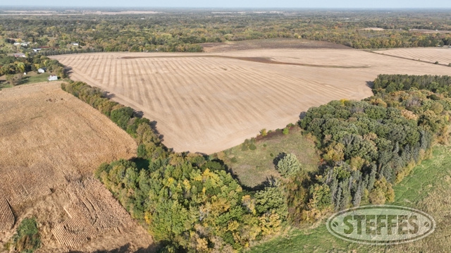
BENTON COUNTY - TRACT 1 - 65.81± ACRES (See Survey, Parcel B)
Land Located: From Gilman, MN, 1.2 miles north on 105th Ave NE. Land is located on the west side of the road.
Description: The South Half of the Southeast Quarter, Section 21, Township 38, Range 29, Benton County, Minnesota, EXCEPT that part of the East 837.00 feet lying northerly of the South 607.00 feet thereof. Subject to 105th Avenue NE on the east and 135th Street NE on the south.
Cropland Acres: Approximately 56.4±
PID #: 01.00256.01 (That part of, new legal & PID# to be assigned)
Soil Productivity Index: 81.2
Soils: Milaca loam, 1 to 7 percent slopes, stony (59.5%), BrennyvilleFreer complex, 1 to 4 percent slopes, stony (39.6%), CebanaGiese, frequently pondedFreer complex, 0 to 3 percent slopes, stony (0.9%)
Taxes (2024): $2,788.00 (For entire land. New tax amount TBD)
Access easement for parcel to the north: An easement for ingress, egress, and utility purposes over, under, and across that part of the South Half of the Southeast Quarter, Section 21, Township 38, Range 29, Benton County, Minnesota, described as follows: Beginning at the intersection with the east line of said South Half of the Southeast Quarter and the north line of the South 607.00 feet of said South Half of the Southeast Quarter; thence South 01 degrees 02 minutes 16 seconds East, assumed bearing, 102.00 feet along said east line of the South Half of the Southeast Quarter; thence North 80 degrees 37 minutes 10 seconds West 418.00 feet; thence South 88 degrees 11 minutes 55 seconds West 460.00 feet; thence North 00 degrees 58 minutes 00 seconds West 595.00 feet; thence North 26 degrees 02 minutes 44 seconds West 101.00 feet; thence North 64 degrees 05 minutes 36 seconds West 102.00 feet; thence South 83 degrees 05 minutes 17 seconds West 312.00 feet; thence North 56 degrees 09 minutes 06 seconds West 102.00 feet to the intersection with the north line of said South Half of the Southeast Quarter; thence North 89 degrees 20 minutes 07 seconds East 561.00 feet along said north line of the South Half of the Southeast Quarter to its intersection with the west line of the East 837.00 feet of said South Half of the Southeast Quarter; thence South 01 degrees 02 minutes 16 seconds East 720.51 feet along said west line of the East 837.00 feet of the South Half of the Southeast Quarter to its intersection with said north line of the South 607.00 feet of the South Half of the Southeast Quarter; thence North 89 degrees 07 minutes 47 seconds East 837.00 feet along said north line of the South 607.00 feet of the South Half of the Southeast Quarter to the point of beginning. Subject to 105th Avenue NE on the east.
BENTON COUNTY - TRACT 2 - 85.30± ACRES (See Survey, Parcel B)
Land Located: From Gilman, MN, 1.9 miles north on 105th Ave NE. Land is located on the west side of the road.
Description: That part of the North Half of the Southeast Quarter and that part of the Northeast Quarter of the Southwest Quarter, all in Section 28, Township 38, Range 29, Benton County, Minnesota, lying easterly and southerly of the following described line: Commencing at the northeast corner of said North Half of the Southeast Quarter; thence South 88 degrees 55 minutes 57 seconds West, assumed bearing, 1147.66 feet along the north line of said North Half of the Southeast Quarter to its intersection with the east line of the West 150.00 feet of the Northeast Quarter of the Southeast Quarter of said Section 28, the point of beginning of said line to be described; thence South 00 degrees 50 minutes 16 seconds East 100.00 feet along said east line of the West 150.00 feet of the Northeast Quarter of the Southeast Quarter to its intersection with the south line of the North 100.00 feet of said North Half of the Southeast Quarter; thence South 88 degrees 55 minutes 57 seconds West 1767.51 feet along said south line of the North 100.00 feet of the North Half of the Southeast Quarter and the south line of the North 100.00 feet of said Northeast Quarter of the Southwest Quarter to its intersection with the west line of the East 320.00 feet of said Northeast Quarter of the Southwest Quarter; thence South 00 degrees 55 minutes 29 seconds East 1234.45 feet along said west line of the East 320.00 feet of the Northeast Quarter of the Southwest Quarter to its intersection with the south line of said Northeast Quarter of the Southwest Quarter and said line there terminating. Subject to 105th Avenue NE on the east.
Cropland Acres: Approximately 80.92±
PID #: 01.00333.00 (That part of, new legal & PID# to be assigned), 01.00334.00 (That part of, new legal & PID# to be assigned), 01.00335.00 (That part of, new legal & PID# to be assigned), & 01.00337.00 (That part of, new legal & PID# to be assigned)
Soil Productivity Index: 78.6
Soils: BrennyvilleFreer complex, 1 to 4 percent slopes, stony (47.7%), Milaca loam, 1 to 7 percent slopes, stony (35.4%), CebanaGiese, frequently pondedFreer complex, 0 to 3 percent slopes, stony (16.9%)
Taxes (2024): $2,600.00 (For entire land. New tax amount TBD)
BENTON COUNTY - TRACT 3 - 173± ACRES (See Survey, Parcel B)
Land Located: From Fruitville, MN, 0.5 miles south on 40th Ave NE towards 95th St. NE, 190’ west on 95th St NE, 2.0 miles south on Town Hall Rd NE. Land is located on the west side of the road.
Description: The North 60 acres of the West Half of the Southwest Quarter, Section 21, Township 37, Range 30, Benton County, Minnesota, EXCEPT the following described parcel: That part of the West Half of the Southwest Quarter, Section 21, Township 37, Range 30, Benton County, Minnesota, described as follows: Beginning at the northeast corner of said West Half of the Southwest Quarter; thence South 02 degrees 18 minutes 44 seconds West, assumed bearing, 877.00 feet along the east line of said West Half of the Southwest Quarter; thence North 82 degrees 18 minutes 08 seconds West 125.00 feet; thence South 50 degrees 59 minutes 15 seconds West 188.00 feet; thence North 68 degrees 24 minutes 54 seconds West 222.00 feet; thence North 24 degrees 12 minutes 07 seconds East 123.00 feet; thence North 02 degrees 43 minutes 47 seconds West 98.00 feet; thence North 42 degrees 02 minutes 11 seconds West 76.87 feet; thence North 02 degrees 18 minutes 44 seconds East 623.00 feet to the intersection with the north line of said West Half of the Southwest Quarter; thence North 89 degrees 14 minutes 14 seconds East 492.39 feet along said north line of the West Half of the Southwest Quarter to the point of beginning. Subject to 80th Street NE on the north and Town Hall Road NE on the east.
Cropland Acres: 144.28±
PID #: 07.00235.00, 07.00236.00, 07.00241.00 & 07.00251.00 (That part of, new legal & PID# to be assigned)
Soil Productivity Index: 79.2
Soils: Milaca loam, 1 to 7 percent slopes, stony (56.1%), MoraRonneby complex, 1 to 4 percent slopes, stony (35.3), CebanaGiese, frequently pondedRonneby complex, 0 to 3 percent slopes, stony (6.2%), Bowstring and Fluvaquents, loamy, 0 to 2 percent slopes, frequently flooded (1.3%), Watab loamy fine sand, 0 to 2 percent slopes (0.8%), Nokasippi loamy fine sand, depressional, 0 to 1 percent slopes (0.3%)
Taxes (2024): $4,404.00 (For entire land. New tax amount TBD)
BENTON COUNTY -TRACT 4 - 78.6± ACRES (See Survey)
Land Located: From Foley, MN, 2.2 miles northeast on MN-23 E, .5 miles south on 145th Ave NE, .4 miles west on 73rd St NE. Land is located on the south side of the road.
Description: The Southwest Quarter of the Northeast Quarter of Section 30, Township 37, Range 28, Benton County, Minnesota. Together with that part of the East Half of the Northwest Quarter, Section 30, Township 37, Range 28, Benton County, Minnesota, lying Southeasterly of the Northwesterly boundary of the abandoned Burlington Northern Railroad Company, right of way, formerly known as the Great Northern Railway right of way. EXCEPTING therefrom: That part of the East Half, of the Northwest Quarter of Section 30, Township 37, Range 28, Benton County, Minnesota, described as follows: Commencing at the North quarter corner of said Section 30; thence South 00 degrees 32 minutes 43 seconds East, assumed bearing along the North-South quarter section line of said Section 30 for 157.95 feet to the point of intersection of the Northwesterly right of way boundary of the abandoned Burlington Northern Railroad Company right of way, formerly known as the Great Northern Railway right-of-way, said point also being the point of beginning; thence continue South 00 degrees 32 minutes 43 seconds East, along the last described line for 1176.48 feet to the southeast corner of the Northeast Quarter of the Northwest Quarter of said Section 30; thence continue South 00 degrees 32 minutes 43 seconds East, along the last described line for 165.00 feet; thence North 90 degrees 00 minutes 00 seconds West for 430.00 feet; thence North 13 degrees 00 minutes 00 seconds West for 230.00 feet; thence North 90 degrees 00 minutes 00 seconds West for 401.72 feet; thence North 00 degrees 00 minutes 00 seconds West for 636.08 feet to the point of intersection with said Northwesterly right-of-way boundary of the abandoned Burlington Northern Railroad Company right of way, formerly known as the Great Northern Railway right of way; thence North 61 degrees 04 minutes 14 seconds. East, along the last described right-of-way boundary for 994.83 feet to the point of beginning. ALSO EXCEPTING therefrom: That part of the Northwest Quarter of Section 30, Township 37, Range 28, Benton County, Minnesota described as follows: Commencing at the southwest corner of said Northwest Quarter; thence North 89 degrees 16 minutes 30 seconds East along the south line of said Northwest Quarter, a distance of 1094.08 feet to the southwest corner of the Southeast Quarter of said Northwest Quarter, also being the point of beginning of the land being described; thence continue North 89 degrees 16 minutes 30 seconds East along said south line, a distance of 616.00 feet; thence North 0 degrees 43 minutes 30 seconds West perpendicular to said south line, a distance of 121.00 feet; thence North 26 degrees 44 minutes 22 seconds West, a distance of 518.00 feet; thence North 39 degrees 37 minutes 54 seconds West, a distance of 79.00 feet; thence South 75 degrees 40 minutes 50 seconds West, a distance of 291.00 feet; thence South 89 degrees 42 minutes 15 seconds West, a distance of 52.00 feet to a point on the west line of said Southeast Quarter of the Northwest Quarter distant 580.00 feet north of said southwest corner of the Southeast Quarter of the Northwest Quarter; thence South 0 degrees 17 minutes 45 seconds East along said west line, a distance of 580.00 feet to the point of
Cropland Acres: 65.12±
PID #: 08.00388.00 (That part of, new legal & PID# to be assigned)
Soil Productivity Index: 61.8
Soils: Ogilvie loam, 0 to 2 percent slopes (44.7%), MilacaBrennyville complex, 1 to 7 percent slopes, stony (28.0%), Warman loam, 0 to 2 percent slopes (10.8%), St. FrancisMahtomedi complex, 2 to 6 percent slopes (8.4%), CebanaGiese, frequently pondedFreer complex, 0 to 3 percent slopes, stony (4.3%), BrennyvilleFreer complex, 1 to 4 percent slopes, stony (2.5%), Novak loam, 0 to 2 percent slopes (1.3%)
Taxes (2024): $2,148.00 (For entire land. New tax amount TBD)
BENTON COUNTY - TRACT 5 - 69.81± ACRES (Not to be surveyed)
Land Located: From Foley, MN, 5.9 miles east on 65th St NE, 2.1 miles south on 185th Ave NE, .3 miles west on 45th St. Land is located on the south side of the road.
Description: See tax statements.
Cropland Acres: 66.84±
PID #: 03.00146.00 & 03.00148.01
Soil Productivity Index: 54.4
Soils: Novak loam, 0 to 2 percent slopes (78.7%), Ogilvie loam, 0 to 2 percent slopes (12.8%), Warman loam, 0 to 2 percent slopes (5.0%), MilacaBrennyville complex, 1 to 7 percent slopes, stony (2.3%), Warman loam, depressional, 0 to 1 percent slopes (1.0%), Seelyeville, occasionally pondedCathro, frequently ponded, complex, 0 to 1 percent slopes (0.2%)
Taxes (2024): $2,254.00
BENTON COUNTY - TRACT 6 - 40± ACRES (Not to be surveyed)
Land Located: From Foley, MN, 4.9 miles east on 65th St NE, 2.2 miles south on 175th Ave NE. Land is on the east side of the road.
Description: Sect-11 Twp-036 Range-028 40.00 AC NW1/4 NW1/4
Cropland Acres: Approximately 3.68±
PID #: 03.00149.00
Soil Productivity Index: 37.2 (For the entire parcel)
Soils: Seelyeville, occasionally pondedCathro, frequently ponded, complex, 0 to 1 percent slopes (41.1%), Warman loam, 0 to 2 percent slopes (34.0%), Warman loam, depressional, 0 to 1 percent slopes (9.5%), BrennyvilleFreer complex, 1 to 4 percent slopes, stony (9.2%), Novak loam, 0 to 2 percent slopes (5.4%), Bowstring and Fluvaquents, loamy, 0 to 2 percent slopes, frequently flooded (0.4%), Ogilvie loam, 0 to 2 percent slopes (0.2%), Nokasippi loamy fine sand, depressional, 0 to 1 percent slopes (0.2%)
Taxes (2024): $558.00
BENTON COUNTY - TRACT 6A - 70.04± ACRES (See Survey, Parcel B)
Land Located: From Foley, MN, 3.9 miles east on 65th St. NE, 1.0 miles south on 165th Ave NE/Benton Co Rd 7, 1.0 miles east on 55th St. NE, 1.5 miles south on 175th Ave NE/Benton County Rd 86. Land is located on the east side of the road.
Description: The South Half of the Northwest Quarter, Section 11, Township 36, Range 28, Benton County, Minnesota, EXCEPT the following described parcel: That part of the South Half of the Northwest Quarter, Section 11, Township 36, Range 28, Benton County, Minnesota, described as follows: Commencing at the southwest corner of said South Half of the Northwest Quarter; thence North 00 degrees 29 minutes 12 seconds East, assumed bearing, 178.00 feet along the west line of said South Half of the Northwest Quarter to the point of beginning; thence continuing North 00 degrees 29 minutes 12 seconds East 33.00 feet along said west line of the South Half of the Northwest Quarter; thence South 89 degrees 02 minutes 06 seconds East 691.61 feet; thence North 00 degrees 50 minutes 49 seconds East 312.00 feet; thence North 88 degrees 58 minutes 01 seconds East 488.00 feet; thence North 03 degrees 19 minutes 32 seconds East 343.00 feet; thence North 88 degrees 58 minutes 01 seconds East 458.24 feet; thence South 00 degrees 50 minutes 49 seconds West 461.46 feet; thence South 71 degrees 10 minutes 10 seconds West 804.00 feet; thence North 80 degrees 05 minutes 33 seconds West 87.00 feet; thence North 89 degrees 04 minutes 08 seconds West 809.00 feet to the point of beginning. Subject to 175th Avenue NE on the west.
Cropland Acres: Approximately 61.03±
PID #: 03.00150.00 (That part of, new legal & PID# to be assigned)
Soil Productivity Index: 42.8
Soils: Novak loam, 0 to 2 percent slopes (45.5%), Warman loam, 0 to 2 percent slopes (22.9%), Warman loam, depressional, 0 to 1 percent slopes (15.4%), Seelyeville, occasionally pondedCathro, frequently ponded, complex, 0 to 1 percent slopes (14.3%), MoraRonneby complex, 1 to 4 percent slopes, stony (1.2%), Bowstring and Fluvaquents, loamy, 0 to 2 percent slopes, frequently flooded (0.7%)
Taxes (2024): $2,888.00 (For entire land. New tax amount TBD)
BENTON COUNTY - TRACT 7 - 79.76± ACRES (Not to be surveyed)
Land Located: From Foley, MN, 3.9 miles east on 65th St. NE, 1.0 miles south on 165th Ave NE/Benton Co Rd 7, 1.0 miles east on 55th St. NE, 1.8 miles south on 175th Ave NE/Benton County Rd 86. Land is located on the west side of the road.
Description: Sect-10 Twp-036 Range-028 79.76 AC N1/2 SE1/4 LESS PART COMM AT SE CORNER SECT 10 TH N 2000 FT TH WLY 1100 FT TO POB TH WLY 100 FT TH NLY 100 FT TH ELY 100 FT TH SLY 100 FT TO POB SUBJ TO DRIVEWAY EASMNT
Cropland Acres: Approximately 75.44±
PID #: 03.00138.00
Soil Productivity Index: 52.3
Soils: MilacaMora complex, 1 to 7 percent slopes, stony (25.3%), Lino loamy fine sand, stratified substratum, 0 to 2 percent slopes (24.1%), Warman loam, depressional, 0 to 1 percent slopes (14.2%), Bushville fine sand, 0 to 2 percent slopes (10.8%), Zimmerman fine sand, 1 to 6 percent slopes (6.9%), CebanaGiese, frequently pondedRonneby complex, 0 to 3 percent slopes, stony (5.8%), Nokasippi loamy fine sand, depressional, 0 to 1 percent slopes (5.3%), MoraRonneby complex, 1 to 4 percent slopes, stony (4.3%), Warman loam, 0 to 2 percent slopes (3.3%)
Taxes (2024): $3,282.00
Livestock Building
Pole Barn
Pole Barn
Pole Barn
Hog Barn
Livestock Building
(2) 5,000 bu. bins
(2) 10,000 bu. bins
Gates, panels, & other livestock equipment not included in the real estate.
BENTON COUNTY - TRACT 8 - 40± ACRES (Not to be surveyed)
Land Located: From Foley, MN, 3.9 miles east on 65th St. NE, 1.0 miles south on 165th Ave NE/Benton Co Rd 7, 1.0 miles east on 55th St. NE, 1.5 miles south on 175th Ave NE/Benton County Rd 86. Land is located on the west side of the road.
Description: Sect-10 Twp-036 Range-028 40.00 AC SE1/4 NE1/4
Cropland Acres: Approximately 34.11±
PID #: 03.00133.00
Soil Productivity Index: 33.9
Soils: Bowstring and Fluvaquents, loamy, 0 to 2 percent slopes, frequently flooded (36.3%), Warman loam, 0 to 2 percent slopes (21.4%), Lino loamy fine sand, stratified substratum, 0 to 2 percent slopes (14.5%), MoraRonneby complex, 1 to 4 percent slopes, stony (13.8%), Warman loam, depressional, 0 to 1 percent slopes (11.4%), Zimmerman fine sand, 1 to 6 percent slopes (1.6%), Seelyeville, occasionally pondedCathro, frequently ponded, complex, 0 to 1 percent slopes (1.0%)
Taxes (2024): $1,382.00
BENTON COUNTY - TRACT 8A - 110.15± ACRES (See Survey, Parcel B & C)
Land Located: From Foley, MN, 3.9 miles east on 65th St. NE, 5.1 miles south on 165th Ave NE/Benton Co Rd 7, .4 miles east on MN-95 E. Land is located on the south side of the road.
Description: That part of the East Half of the Northwest Quarter, Section 27, Township 36, Range 28, Benton County, Minnesota, described as follows: Commencing at the northwest corner of said East Half of the Northwest Quarter; thence South 89 degrees 51 minutes 57 seconds East 338.76 feet along the north line of said East Half of the Northwest Quarter to the point of beginning; thence South 00 degrees 16 minutes 36 seconds West 2217.15 feet to the intersection with the north line of the South 438.00 feet of said East Half of the Northwest Quarter; thence South 89 degrees 36 minutes 06 seconds East 969.45 feet along said north line of the South 438.00 feet of the East Half of the Northwest Quarter to its intersection with the east line of said East Half of the Northwest Quarter; thence North 00 degrees 28 minutes 04 seconds East 2221.65 feet along said east line of the East Half of the Northwest Quarter to the northeast corner thereof; thence North 89 degrees 51 minutes 57 seconds West 976.86 feet along said north line of the East Half of the Northwest Quarter to the point of beginning. Subject to 168th Avenue NE on the west and State Highway 95 NE on the north. & That part of the East Half of the Northwest Quarter, Section 27, Township 36, Range 28, Benton County, Minnesota, described as follows: Beginning at the northwest corner of said East Half of the Northwest Quarter; thence South 89 degrees 51 minutes 57 seconds East 338.76 feet along the north line of said East Half of the Northwest Quarter; thence South 00 degrees 16 minutes 36 seconds West 2217.15 feet to the intersection with the north line of the South 438.00 feet of said East Half of the Northwest Quarter; thence North 89 degrees 36 minutes 06 seconds West 26.55 feet along said north line of the South 438.00 feet of the East Half of the Northwest Quarter to its intersection with the west line of the East 996.00 feet of said East Half of the Northwest Quarter; thence South 00 degrees 28 minutes 04 seconds West 438.00 feet along said west line of the East 996.00 feet of the East Half of the Northwest Quarter to its intersection with the south line of said East Half of the Northwest Quarter; thence North 89 degrees 36 minutes 06 seconds West 317.27 feet along said south line of the East Half of the Northwest Quarter to the southwest corner thereof; thence North 00 degrees 25 minutes 03 seconds East 2653.58 feet along the west line of said East Half of the Northwest Quarter to the point of beginning. Subject to 168th Avenue NE on the east and State Highway 95 NE on the north & NE1/4 SW1/4
Cropland Acres: Approximately 101.98±
PID #: 03.00379.00 (That part of, new legal & PID# to be assigned) & 03.00386.00
Soil Productivity Index: 48.3
Soils: Warman loam, depressional, 0 to 1 percent slopes (34.0%), MoraRonneby complex, 1 to 4 percent slopes, stony (21.2%), CebanaGiese, frequently pondedRonneby complex, 0 to 3 percent slopes, stony (17.4%), MilacaMora complex, 1 to 7 percent slopes, stony (15.3%), CathroTwig, stony complex, 0 to 1 percent slopes, frequently ponded (12.1%)
Taxes (2024): $4,906.00 (For entire land. New tax amount TBD)
SHERBURNE COUNTY - TRACT 9 - 77.72± ACRES (Not to be surveyed)
Land Located: From Becker, MN, 5.1 miles north on County Rd 23 SE. Land is on the east side of the road.
Description: Sect-8 Twp-34 Range-28 ALL THAT PART OF S 1/2 OF NE 1/4 EXCEPT THE PORTION DESC AS FOLL: COMM AT NW CORNER OF S 1/2 OF NE 1/4; THENCE ON AN ASSUMED BEARING OF S 00 DEG 14 MIN 09 SEC E ALONG W LINE OF S 1/2 OF NE 1/4 DIST 185 FT TO POB; THENCE S 82 DEG 30 MIN 00 SEC E DIST 466 FT; THENCE S 15 DEG 30 MIN 00 SEC W DIST 280 FT; THENCE N 78 DEG 30 MIN 00 SEC W DIST 394.06 FT MORE OR LESS TO INTERSECT SAID W LINE OF S 1/2 OF NE 1/4; THENCE N 00 DEG 14 MIN 09 SEC W ALONG SAID W LINE TO POB OF THE TRACT HEREIN DESC.
Cropland Acres: 55.18±
PID #: 05-00108-1400
Soil Productivity Index: 58.3
Soils: Braham loamy fine sand, 3 to 6 percent slopes (31.8%), Braham loamy fine sand, 6 to 12 percent slopes (12.8%), Beltrami fine sandy loam, 0 to 3 percent slopes (12.0%), Seelyeville muck, 0 to 1 percent slopes (11.4%), Talmoon loam, 0 to 2 percent slopes (9.6%), Braham loamy fine sand, 12 to 18 percent slopes (5.2%), Nebish fine sandy loam, 12 to 18 percent slopes (4.3%), Nebish fine sandy loam, 6 to 12 percent slopes (3.3%), Ricelake fine sandy loam, 0 to 3 percent slopes (3.3%), Eckvoll loamy fine sand, 0 to 3 percent slopes (3.2%), Cathro muck, 0 to 1 percent slopes (2.6%), Nebish fine sandy loam, 2 to 6 percent slopes (0.5%)
Taxes (2024): $3,670.00
SHERBURNE COUNTY - TRACT 10 – 80.07± ACRES (Not to be surveyed)
Land Located: From Becker, MN, 2.6 miles north on County Rd 23 SE, .3 miles east on 97th St., .7 miles north on Filly Trail. Land is located on the east side of the road.
Description: Sect-18 Twp-34 Range-28 SW 1-4 OF NE 1-4 SE OF ROAD & E 1-2 OF NE 1-4 EX W 580 FT OF NE 1-4 OF NE 1-4 LYING N OF CTY RD.
Cropland Acres: Approximately 72.73±
PID #: 05-00118-1300 & 05-00118-1100
Soil Productivity Index: 50.4
Soils: Isanti loamy fine sand, 0 to 2 percent slopes (26.5%), Talmoon loam, 0 to 2 percent slopes (17.9%), Markey muck, occasionally ponded, 0 to 1 percent slopes (13.2%), Braham loamy fine sand, 3 to 6 percent slopes (10.2%), Lino loamy fine sand, 0 to 2 percent slopes (9.7%), Nebish fine sandy loam, 2 to 6 percent slopes (8.8%), Zimmerman fine sand, 1 to 6 percent slopes (3.9%), Eckvoll loamy fine sand, 0 to 3 percent slopes (2.6%), Nebish fine sandy loam, 12 to 18 percent slopes (2.2%), Ricelake fine sandy loam, 0 to 3 percent slopes (2.2%), Duelm loamy sand, 0 to 2 percent slopes (1.7%), Nebish fine sandy loam, 6 to 12 percent slopes (1.1%)
Taxes (2024): $2,816.00
SHERBURNE COUNTY - TRACT 11 – 72.55± ACRES (Not to be surveyed)
Land Located: From Becker, MN, 2.6 miles north on County Rd 23 SE, .3 miles east on 97th St., .3 miles north on Filly Trail. Land is located on the east side of the road.
Description: Sect-18 Twp-34 Range-28 N 1-2 OF SE 1-4 EX PT LYING W OF TRUNK HIGHWAY 218.
Cropland Acres: Approximately 60.24±
PID #: 05-00118-4100
Soil Productivity Index: 67.2
Soils: Nebish fine sandy loam, 2 to 6 percent slopes (56.9%), Nebish fine sandy loam, 6 to 12 percent slopes (18.1%), Markey muck, occasionally ponded, 0 to 1 percent slopes (12.1%), Duelm loamy sand, 0 to 2 percent slopes (4.3%), Braham loamy fine sand, 3 to 6 percent slopes (3.3%), Isanti loamy fine sand, 0 to 2 percent slopes (2.1%), Ricelake fine sandy loam, 0 to 3 percent slopes (1.9%), Lino loamy fine sand, 0 to 2 percent slopes (0.9%), Talmoon loam, 0 to 2 percent slopes (0.4%)
Taxes (2024): $2,768.00
DOUGLAS COUNTY - TRACT 12 – 160± ACRES (Not to be surveyed)
Land Located: From Nelson, MN, 1.0 miles east on Hope Ave W, .7 miles north on County Rd 74 NE. Land is located on the east side of the road.
Description: Sect-17 Twp-128 Range-36 NW4. AC 160 (SUBJECT TO CO RD 74 HWY ESMT)
Cropland Acres: 99.69±
PID #: 51-0217-000
Soil Productivity Index: 78.3
Soils: Vallers clay loam, 0 to 2 percent slopes (37.8%), Gonvick loam, 1 to 4 percent slopes (31.7%), Cathro muck, occasionally ponded, 0 to 1 percent slopes (14.8%), Quam silty clay loam, occasionally ponded, 0 to 1 percent slopes (6.4%), Waukon loam, 2 to 6 percent slopes (4.5%), LakeparkParnell, occasionally ponded, complex, 0 to 2 percent slopes (3.0%), Haslie, Seelyeville, and Cathro soils, frequently ponded, 0 to 1 percent slopes (1.8%)
Taxes (2024): $4,212.00
TERMS: Ten percent down upon signing purchase agreement, payable by cash or check. Balance due at closing within 30-45 days, must close in 2024. This is a 5% buyer’s premium auction.