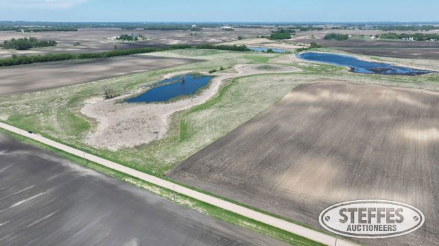
Wright County, MN – Stockholm Township
Total Acres: 99.79±
PID #: 218-000-043100, 218-000-043101, 218-000-043200, & 218-000-042100 (part)
To Be Sold in 2 Tracts!
TRACT 1:
Description: The North 36 rods of the East 44 rods of the Northwest Quarter of the Southwest Quarter (NW1/4 of SW1/4) of Section Four (4), Township One Hundred Eighteen (118), Range Twenty-eight (28), Wright County, Minnesota. AND The North 36 rods of the East Half of the Southwest Quarter (E1/2 of 52.64± (See survey, Tract 1)the SW1/4) of Section 4, Township 118, Range 28, Wright County, Minnesota. AND The East 330.00 feet of the East Half of the Southwest Quarter (E1/2 of the SW1/4) lying southerly of the North 36 rods of said (E1/2 of the SW1/4) of Section 4, Township 118, Range 28, Wright County, Minnesota. AND That part of the Southeast Quarter of the Northwest Quarter of Section 4, Township 118, Range 28, Wright County, Minnesota, described as follows: Commencing at the southwest corner of said Southeast Quarter of the Northwest Quarter; thence on an assumed bearing of South 89 degrees 05 minutes 01 seconds East, along the south line of said Southeast Quarter of the Northwest Quarter, a distance of 18.21 feet to the point of beginning; thence North 36 degrees 29 minutes 30 seconds East, a distance of 66.11 feet; thence North 01 degrees 51 minutes 05 seconds West, a distance of 197.96 feet; thence North 02 degrees 38 minutes 38 seconds East, a distance of 403.66 feet; thence northeasterly 147.23 feet along a tangential curve, concave to the southeast, having a radius of 143.50 feet and a central angle of 58 degrees 47 minutes 03 seconds; thence North 61 degrees 25 minutes 41 seconds East, tangent to the previously described curve, a distance of 115.51 feet; thence South 00 degrees 34 minutes 20 seconds East, a distance of 102.27 feet; thence South 38 degrees 22 minutes 14 seconds East, a distance of 592.83 feet; thence South 57 degrees 52 minutes 12 seconds East, a distance of 523.58 feet, to said south line of the Southeast Quarter of the Northwest Quarter; thence North 89 degrees 05 minutes 01 seconds West, along said south line of the Southeast Quarter of the Northwest Quarter, a distance of 1040.24 feet to the point of beginning.
Total Acres:
Cropland Acres: Approximately 9.54±
PID #: 218-000-043101 (That part of, new legal & PID# to be assigned), 218-000-043100 (That part of, new legal & PID# to be assigned), 218-000-042100(That part of, new legal & PID# to be assigned), & 218-000-043200
Crop Productivity Index: 86.4
Soils: CokatoStorden complex, 6 to 12 percent slopes, eroded (60.9%), ReedslakeLe Sueur complex, 1 to 6 percent slopes (17.5%), Cordova clay loam, 0 to 2 percent slopes (16.4%), CokatoStorden complex, 12 to 18 percent slopes, eroded (4.6%), Canisteo clay loam, 0 to 2 percent slopes (0.6%)
Taxes (2026): $5,448.00 (For entire land. New tax amount TBD)
Being sold subject to the Perpetual Conservation Easement for Wetland Bank signed on January 18, 2023.
TRACT 2:
Description: That part of the East Half of the Southwest Quarter (E1/2 of the SW1/4) of Section 4, Township 118, Range 28, Wright County, Minnesota, lying southerly of the North 36 rods of said E1/2 of the SW1/4 and lying westerly of the East 330.00 feet of said E1/2 of the SW1/4.
Total Acres: 47.15± (See survey, Tract 2)
Cropland Acres: Approximately 10.32±
PID #: 218-000-043101 (That part of, new legal & PID# to be assigned) & 218-000-043100 (That part of, new legal & PID# to be assigned)
Crop Productivity Index: 90.2
Soils: ReedslakeLe Sueur complex, 1 to 6 percent slopes (54.3%), CokatoStorden complex, 12 to 18 percent slopes, eroded (15.8%), CokatoStorden complex, 6 to 12 percent slopes, eroded (13.2%), ReedslakeSwanlake complex, 3 to 12 percent slopes (8.3%), Canisteo clay loam, 0 to 2 percent slopes (7.2%), Cordova clay loam, 0 to 2 percent slopes (1.2%)
Taxes (2026): $1,864.00 (For entire land. New tax amount TBD)
Being sold subject to the Perpetual Conservation Easement for Wetland Bank signed on January 18, 2023.
TERMS: Ten percent down upon signing purchase agreement, payable by cash or check. Balance due at closing within 30 days. This is a 5% buyer’s fee auction.
CONTACT