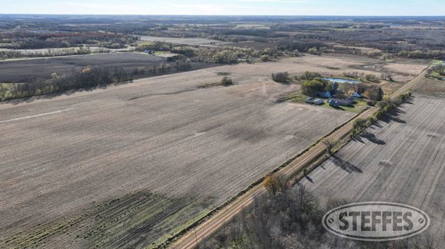
Meeker County, MN – Forest Prairie Township
Description: That part of the North Half of the Northeast Quarter (N1/2 of the NE1/4) of Section 19, Township 121 North, Range 30 West, Meeker County, Minnesota, described as follows: Commencing at the Northeast corner of said Section 19; thence on an assumed bearing of South 89 degrees 26 minutes 26 seconds West along the north line of said N1/2 of the NE1/4, 770.21 feet to the point of beginning of the tract of land herein described; thence continue South 89 degrees 26 minutes 26 seconds West along last said line, 946.10 feet; thence South 00 degrees 47 minutes 46 seconds East, parallel with the east line of said N1/2 of the NE1/4, 406.48 feet; thence North 89 degrees 26 minutes 26 seconds East, parallel with the north line of said N1/2 of the NE1/4, 946.10 feet; thence North 00 degrees 47 minutes 46 seconds West, parallel with the east line of said N1/2 of the NE1/4, 406.48 feet to the point of beginning and there terminating. & The North Half of the Northeast Quarter (N1/2 of the NE1/4) of Section 19, Township 121 North, Range 30 West, Meeker County, Minnesota. EXCEPT That part of the North Half of the Northeast Quarter (N1/2 of the NE1/4) of Section 19, Township 121 North, Range 30 West, Meeker County, Minnesota, described as follows: Commencing at the Northeast corner of said Section 19; thence on an assumed bearing of South 89 degrees 26 minutes 26 seconds West along the north line of said N1/2 of the NE1/4, 770.21 feet to the point of beginning of the tract of land herein described; thence continue South 89 degrees 26 minutes 26 seconds West along last said line, 946.10 feet; thence South 00 degrees 47 minutes 46 seconds East, parallel with the east line of said N1/2 of the NE1/4, 406.48 feet; thence North 89 degrees 26 minutes 26 seconds East, parallel with the north line of said N1/2 of the NE1/4, 946.10 feet; thence North 00 degrees 47 minutes 46 seconds West, parallel with the east line of said N1/2 of the NE1/4, 406.48 feet to the point of beginning and there terminating. & The Northwest Quarter of the Northwest Quarter (NW1/4 of the NW1/4) of Section 20, Township 121 North, Range 30 West, Meeker County, Minnesota.
Total Acres: 120.83±
PID #: 10-0205000 & 10-0212000
To Be Sold in 3 Tracts!
TRACT 1:
Description: The Northwest Quarter of the Northwest Quarter (NW1/4 of the NW1/4) of Section 20, Township 121 North, Range 30 West, Meeker County, Minnesota.
Total Acres: 41.29±
Cropland Acres: Approximately 38.56±
PID #: 10-0212000 (See survey, Tract C)
Crop Productivity Index: 85.1
Soils: Koronis loam, 2 to 6 percent slopes (47.6%), Barry loam, 0 to 2 percent slopes (17.6%), Darfur loam, 0 to 2 percent slopes (11.3%), Forestcity, overwashForestcity complex, 1 to 4 percent slopes (9.8%), Litchfield loamy fine sand, 0 to 2 percent slopes (7.1%), Koronis loam, 6 to 10 percent slopes, moderately eroded (6.6%)
Taxes (2025): $2,066.00
NO US Fish & Wildlife Easement
TRACT 2:
Description: The North Half of the Northeast Quarter (N1/2 of the NE1/4) of Section 19, Township 121 North, Range 30 West, Meeker County, Minnesota. EXCEPT That part of the North Half of the Northeast Quarter (N1/2 of the NE1/4) of Section 19, Township 121 North, Range 30 West, Meeker County, Minnesota, described as follows: Commencing at the Northeast corner of said Section 19; thence on an assumed bearing of South 89 degrees 26 minutes 26 seconds West along the north line of said N1/2 of the NE1/4, 770.21 feet to the point of beginning of the tract of land herein described; thence continue South 89 degrees 26 minutes 26 seconds West along last said line, 946.10 feet; thence South 00 degrees 47 minutes 46 seconds East, parallel with the east line of said N1/2 of the NE1/4, 406.48 feet; thence North 89 degrees 26 minutes 26 seconds East, parallel with the north line of said N1/2 of the NE1/4, 946.10 feet; thence North 00 degrees 47 minutes 46 seconds West, parallel with the east line of said N1/2 of the NE1/4, 406.48 feet to the point of beginning and there terminating.
Total Acres: 70.71± (See survey, Tract B)
Cropland Acres: Approximately 59.5±
PID #: 10-0205000 (That part of, new legal & PID# to be assigned)
Crop Productivity Index: 71.7
Soils: Litchfield loamy fine sand, 0 to 2 percent slopes (27.2%), Darfur loam, 0 to 2 percent slopes (17.6%), RohrbeckKoronis complex, 1 to 6 percent slopes (16.1%), Granby fine sandy loam, 0 to 1 percent slopes (15.8%), Koronis loam, 2 to 6 percent slopes (9.4%), Barry loam, 0 to 2 percent slopes (7.9%), Sparta loamy sand, 1 to 6 percent slopes (3.1%), Marcellon loam, 0 to 3 percent slopes (1.5%), Dassel mucky fine sandy loam, depressional, 0 to 1 percent slopes (1.2%), Medo, Dassel and Biscay soils, ponded, 0 to 1 percent slopes (0.2%)
Taxes (2025): $5,266.00 (For entire land. New tax amount TBD)
NO US Fish & Wildlife Easement
TRACT 3:
Description: That part of the North Half of the Northeast Quarter (N1/2 of the NE1/4) of Section 19, Township 121 North, Range 30 West, Meeker County, Minnesota, described as follows: Commencing at the Northeast corner of said Section 19; thence on an assumed bearing of South 89 degrees 26 minutes 26 seconds West along the north line of said N1/2 of the NE1/4, 770.21 feet to the point of beginning of the tract of land herein described; thence continue South 89 degrees 26 minutes 26 seconds West along last said line, 946.10 feet; thence South 00 degrees 47 minutes 46 seconds East, parallel with the east line of said N1/2 of the NE1/4, 406.48 feet; thence North 89 degrees 26 minutes 26 seconds East, parallel with the north line of said N1/2 of the NE1/4, 946.10 feet; thence North 00 degrees 47 minutes 46 seconds West, parallel with the east line of said N1/2 of the NE1/4, 406.48 feet to the point of beginning and there terminating.
Total Acres: 8.83± (See survey, Tract A)
PID #: 10-0205000 (That part of, new legal & PID# to be assigned)
Taxes (2025): $5,266.00 (For entire land. New tax amount TBD)
No US Fish & Wildlife Easement
House Details
Grain bin with sweep auger
Silo with unloader
Outbuilding Details
Building A
Building B
Building C
Building D
Barn
Building F
Red roof buildings new roofs in 2019
All buildings have power
(1) Ritchie waterer
TERMS: Ten percent down upon signing purchase agreement, payable by cash or check. Balance due at closing within 30 days. This is a 5% buyer’s premium auction.