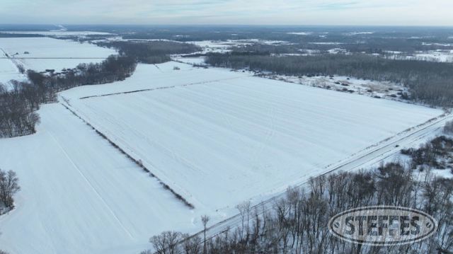
AITKIN COUNTY, MN – SPENCER TOWNSHIP
Total Acres: 502.23±
PID #: 31-0-010000, 31-0-030700, 31-0-030600, 31-0-032101, 31-0-030801, 31-0-039203, 31-0-039204, 31-0-040200 & 31-0-040100
To Be Sold in 8 Tracts!
TRACT 1:
Description: SEC: 4 TWP: 47.0 RG:26 S 1/2 OF SE LESS HWY
Total Acres: 79.80±
PID #: 31-0-010000
Taxes (2025): $780.00
NO US Fish & Wildlife Easement
TRACT 2:
Description: SEC:16 TWP: 47.0 RG:26 ALL PART OF NW OF NW, NW OF HY 210 LESS HWY & ALL PART OF NE OF NW, NW OF HWY 210 LESS HWY
Total Acres: 45.38±
Cropland Acres: 46.43±
PID #: 31-0-030700 & 31-0-030600
Crop Productivity Index: 44.5
Soils: Waukenabo fine sandy loam (44.0%), Leafriver muck (32.3%), Sago muck, 0 to 1 percent slopes, frequently ponded (13.1%), Willosippi loam (10.3%), Cathro muck, stratified substratum (0.3%)
Taxes (2025): $474.00
NO US Fish & Wildlife Easement
TRACT 3:
Description: The Northeast Quarter (NE1/4) and the Southeast Quarter of the Northwest Quarter (SE1/4 of the NW1/4), all being in Section 17, Township 47 North, Range 26 West, Aitkin County, Minnesota. AND That part of the Northwest Quarter of the Southeast Quarter (NW1/4 of the SE1/4) and that part of the Northeast Quarter of the Southwest Quarter (NE1/4 of the SW1/4), all being in Section 17, Township 47 North, Range 26 West, Aitkin County, Minnesota, lying northerly of the following described line: Commencing at the East Quarter corner of said Section 17; thence on an assumed bearing of South 89 degrees 22 minutes 06 seconds West along the north line of the Northeast Quarter of the Southeast Quarter (NE1/4 of the SE1/4) of said Section 17, 1338.14 feet to the northwest corner of said NE1/4 of the SE1/4; thence South 01 degrees 18 minutes 51 seconds East along the east line of said NW1/4 of the SE1/4, 14.35 feet to the point of beginning of the line herein described; thence South 88 degrees 52 minutes 15 seconds West, 528.64 feet; thence South 88 degrees 16 minutes 52 seconds West, 611.59 feet; thence North 89 degrees 36 minutes 09 seconds West, 445.56 feet; thence South 88 degrees 32 minutes 10 seconds West, 460.08 feet; thence South 87 degrees 14 minutes 23 seconds West, 337.71 feet; thence North 89 degrees 51 minutes 37 seconds West, 294.73 feet to the west line of said NE1/4 of the SW1/4 and said line terminating thereat. EXCEPT The East Quarter of the Northeast Quarter of the Northeast Quarter of Section 17, Township 47 North, Range 26 West, Aitkin County, Minnesota.
Total Acres: 190.54±
Cropland Acres: Approximately 109.15±
PID #: 31-0-032101 (That part of, new legal & PID# to be assigned)
Crop Productivity Index: 37.9
Soils: Waukenabo fine sandy loam (30.2%), Sago muck, 0 to 1 percent slopes, frequently ponded (29.9%), Redby loamy fine sand, stratified substratum (20.9%), Cathro muck, stratified substratum (19.0%)
Taxes (2025): $2,632.00 (For entire land. New tax amount TBD)
NO US Fish & Wildlife Easement
TRACT 4:
Description: SEC:16 TWP: 47.0 RG:26 PT SW NW W OF HWY 169 LESS HWY
Total Acres: 20.05±
Cropland Acres: 20.05±
PID #: 31-0-030801
Crop Productivity Index: 17.3
Soils: Cathro muck, stratified substratum (47.7%), Leafriver muck (39.9%), Waukenabo fine sandy loam (12.4%)
Taxes (2025): $168.00
NO US Fish & Wildlife Easement
TRACT 5:
Description: SEC:20 TWP: 47.0 RG:26 N 1/2 OF NW 1/4 LESS PART IN DOC 340541
Total Acres: 70.00±
Cropland Acres: 53.51±
PID #: 31-0-039203
Crop Productivity Index: 20.5
Soils: Sago muck, 0 to 1 percent slopes, frequently ponded (88.4%), Cormant loamy fine sand, stratified substratum (10.4%), Pengilly silt loam (1.2%)
Taxes (2025): $606.00
NO US Fish & Wildlife Easement
TRACT 6:
Description: That part of the Northwest Quarter of the Northeast Quarter (NW1/4 of the NE1/4) of Section 20, Township 47 North, Range 26 West, Aitkin County, Minnesota, lying westerly of the MINNESOTA DEPARTMENT OF TRANSPORTATION RIGHT OF WAY PLAT NO. 01-16 and lying westerly of the MINNESOTA DEPARTMENT OF TRANSPORTATION RIGHT OF WAY PLAT NO. 01-17, according to the recorded plats thereof, Aitkin County, Minnesota.
Total Acres: 19.56±
Cropland Acres: Approximately 15.46±
PID #: 31-0-039204 (That part of, new legal & PID# to be assigned)
Crop Productivity Index: 5
Soils: Cathro muck, stratified substratum (82.1%), Lupton muck (17.1%), Pengilly silt loam (0.8%)
Taxes (2025): $306.00 (For entire land. New tax amount TBD)
NO US Fish & Wildlife Easement
TRACT 7:
Description: SEC:21 TWP: 47.0 RG:26 NW OF NE
Total Acres: 40±
Cropland Acres: 40±
PID #: 31-0-040200
Crop Productivity Index: 5
Soils: Lupton muck (100%)
Taxes (2025): $174.00
NO US Fish & Wildlife Easement
TRACT 8:
Description: SEC:21 TWP: 47.0 RG:26 NE NE
Total Acres: 40±
PID #: 31-0-040100
Taxes (2025): $30.00
NO US Fish & Wildlife Easement
TERMS: Ten percent down upon signing purchase agreement, payable by cash or check. Balance due at closing within 30 days. This is a 5% buyer’s premium auction.
CONTACT