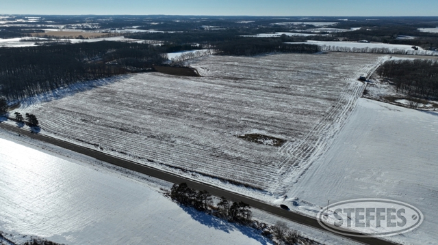
Morrison County, MN – Flensburg & Swanville Township
Total Acres: 313.56±
PID #: 31.0003.000, 31.0004.000, 31.0003.000, 31.0003.001, 36.0021.000, 36.0020.000, & 36.0030.000
To Be Sold in 4 Tracts!
TRACT 1:
Description: Section 01 Township-128 Range-31 N1/2 OF SE1/4
Total Acres: 79.46± (See Survey, Tract 1)
Cropland Acres: Approximately 68.03±
PID #: 31.0002.000
Crop Productivity Index: 78.7
Soils: Brainerd sandy loam, 1 to 4 percent slopes (39.5%), Flak sandy loam, 8 to 15 percent slopes (27.8%), Nokay loam (22.2%), Flak sandy loam, 4 to 8 percent slopes (9.6%), Cathro muck, occasionally ponded, 0 to 1 percent slopes (0.5%), CushingMahtomediDeMontreville complex, 8 to 15 percent slopes (0.4%)
Taxes (2024): $1,334.00
Will give Tract 2 an ingress/egress easement: PROPOSED DESCRIPTION FOR EASEMENT An ingress and egress easement over and across the North 70.00 feet of the East 1 DO.DO feet of the North Half of the Southeast Quarter (N1I2 SE1/4) of Section 1, Township 128, Range 31, Morrison County, Minnesota.
TRACT 2:
The North 60 acres of the South Half of the Northeast Quarter (S1/2 NE1/4) and the South Half of the South Half of the South Half of the Northeast Quarter (S1/2 S1/2 S1/2 NE1/4), all being in Section 1, Township 128, Range 31, Morrison County, Minnesota. EXCEPT The North 50.00 feet of the North 60 acres of the South Half of the Northeast Quarter (S1I2 NE1/4) of Section 1, Township 128, Range 31, Morrison County, Minnesota.
Total Acres: 76.85± (See Survey, Tract 2)
Cropland Acres: Approximately 64.47±
PID #: 31.0004.000, 31.0003.000, 31.0003.001
Crop Productivity Index: 81.5
Soils: Flak sandy loam, 4 to 8 percent slopes (45.7%), Nokay loam (37.0%), Brainerd sandy loam, 1 to 4 percent slopes (13.8%), Flak sandy loam, 8 to 15 percent slopes (2.3%), Parent loam (0.9%), Prebish loam (0.3%)
Taxes (2024): $1,320.00
Will receive an ingress/egress easement from Tract 1: PROPOSED DESCRIPTION FOR EASEMENT An ingress and egress easement over and across the North 70.00 feet of the East 1 DO.DO feet of the North Half of the Southeast Quarter (N1I2 SE1/4) of Section 1, Township 128, Range 31, Morrison County, Minnesota.
TRACT 3:
Description: The West Half of the Southeast Quarter r,N1/2 SE1/4), Section Thirty-one (31), Township One Hundred Twenty-nine (129), Range Thirty (30), less that part lying easterly of the following described line, to-wit: Commencing at the northeast corner of said Southeast Quarter; thence South 00 degrees 19 minutes 59 seconds East, assumed bearing 330.00 feet along the east line of said Southeast Quarter; thence North 89 degrees 47 minutes 19 seconds West, parallel with the north line of said Southeast Quarter, 1314.87 feet to the west line of the East Half of the Southeast Quarter, the point of beginning; thence South 00 degrees 16 minutes 23 seconds East 422.24 feet along said west line of the East Half of the Southeast Quarter; thence South 01 degrees 57 minutes 58 seconds West 584.97 feet; thence continuing South 01 degrees 57 minutes 58 seconds West 1282.00 feet to said south line of the Southeast Quarter and there terminating.
Total Acres: 77.62± (See Survey, Tract 3)
Cropland Acres: Approximately 35.48±
PID #: 31.0004.000, 31.0003.000, 31.0003.001
Crop Productivity Index: 74.3
Soils: Brainerd sandy loam, 1 to 4 percent slopes (65.4%), Nokay loam (13.4%), Parent loam (11.5%), RifleRifle, ponded, complex, 0 to 1 percent slopes (7.2%), Prebish loam (2.5%)
Taxes (2024): $1,066.00
TRACT 4:
Description: Section 31 Township 129 Range 030 N1/2 OF SW1/4
Total Acres: 79.63± (See Survey, Tract 4)
Cropland Acres: Approximately 14.69±
PID #: 36.0030.000
Crop Productivity Index: 81.3
Soils: Brainerd sandy loam, 1 to 4 percent slopes (87.7%), Parent loam (6.9%), Nokay loam (4.3%), RifleRifle, ponded, complex, 0 to 1 percent slopes (1.1%)
Taxes (2024): $910.00
TERMS: Ten percent down upon signing purchase agreement, payable by cash or check. Balance due at closing within 30 days. This is a 5% buyer’s premium auction.